

Abstract
Eine Inertial Navigation System (INS) is a self-contained navigation technology that uses motion sensors, such as accelerometers and gyroscopes, to determine a vehicle’s position, velocity, and orientation. In contrast, a Global Positioning System (GPS) provides absolute position updates from satellites.
According to research and technical references from the National Institute of Standards and Technology, as well as navigation engineering literature summarising systems used across aerospace and autonomous robotics, an INS alone can compute continuous movement through dead reckoning; however, it suffers from cumulative drift over time.
GPS, on the other hand, provides highly accurate global positioning, but it depends on satellite visibility and can be disrupted in tunnels, urban canyons, or under jamming conditions.
Modern navigation architectures therefore combine both systems to create a GPS-aided inertial navigation system (GPS/INS), in which the GPS corrects long-term drift and the INS maintains high-frequency motion tracking between satellite updates. This sensor fusion approach is typically implemented using Kalman filtering techniques to produce stable, real-time navigation outputs with a high level of accuracy for applications in the fields of aerospace, automotive, marine, and robotics.
Introduction: Why INS + GPS Integration Matters
Modern navigation is not about choosing between INS and GPS; it is about combining the two to create a robust hybrid positioning system that can function in all environments.
A standalone GPS provides accurate absolute positioning, but it can fail when:
- Signals are blocked (e.g., in tunnels, buildings, or forests);
- Signals are jammed or spoofed;
- Satellite visibility is limited.
Meanwhile, an INS can operate anywhere, but suffers from:
- Gradual drift accumulation;
- Integration errors over time;
- Sensor bias and noise.
This trade-off is why integrated navigation systems are now standard in:
- Aircraft and UAVs
- Autonome Fahrzeuge
- Schifffahrt
- Missile and defence systems
- Robotics and industrial automation
As explained in navigation system research, INS provides continuity, while GPS corrects. This combination is significantly more reliable than either system alone.
What Is an Inertial Navigation System (INS)?
An Inertial Navigation System (INS) is a self-contained navigation solution that uses motion sensors to calculate position, velocity, and orientation without external references.
Core Definition
INS = IMU (accelerometers + gyroscopes) + computing unit + navigation algorithm
It works on the principle of dead reckoning, where:
- Acceleration is measured
- Velocity is computed by integration
- Position is computed by second integration
However, this process introduces drift over time due to sensor noise and bias accumulation.
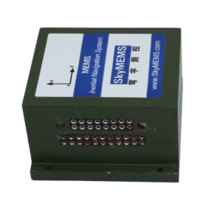
INS Sensor Components
| Komponente | Funktion |
| Beschleunigungsmesser | Misst die lineare Beschleunigung |
| Gyroskop | Misst die Winkelgeschwindigkeit |
| Processing Unit | Computes navigation solution |
| Optional sensors | Magnetometer, barometer, GNSS |
INS Strengths
Works without external signals
High update rate (100–1000 Hz)
Resistant to jamming
Provides continuous motion tracking
INS Weakness
Position drift over time
Requires calibration
Error accumulation during integration
What Is GPS in Navigation Systems?
The Global Positioning System (GPS) is a satellite-based navigation system that provides the following:
- Absolute global position;
- Velocity estimation;
- Time synchronisation.
Unlike INS, GPS does not drift, but it depends on external satellite signals.
-
Strengths of GPS:
- High absolute accuracy
- Global coverage
- No internal drift
GPS weaknesses:
- Signal blockage
- Lower update rate
- Vulnerability to interference
Why Combine INS and GPS? (Core Concept)
The integration of INS and GPS solves the limitations of each system.
Key Idea
INS = continuous short-term accuracy
GPS = long-term absolute correction
This complementary relationship is the foundation of modern navigation systems.
INS vs GPS Behavior Over Time
| Merkmal | INS Alone | GPS Alone | INS + GPS |
| Short-term accuracy | Hoch | Hoch | Sehr hoch |
| Long-term stability | Low (drift) | Hoch | Sehr hoch |
| Signal dependency | None | Required | Hybrid |
| Reliability in tunnels | Hoch | Niedrig | Hoch |
How GPS-Aided INS Works (Sensor Fusion)?
The integration of GPS and INS is typically achieved using a Kalman Filter, a mathematical algorithm that continuously updates system estimates.
Step-by-Step Process:
Step 1: INS Computes Motion Continuously
Accelerometers measure movement
Gyroscopes measure rotation
The system integrates data in real time
Step 2: GPS Provides Absolute Fix
Satellite signals provide a position update
Typically, every 1 second
Step 3: Error Calculation
The difference between INS estimate and the GPS reading is computed
Step 4: Correction via Kalman Filter
INS drift is corrected
Future predictions are adjusted
Step 5: Continuous Fusion Output
Smooth, high-frequency, drift-free navigation result
This fusion is widely used in autonomous systems and aerospace navigation.
INS/GPS Architecture Overview
System Structure
IMU (core INS sensors)
GPS receiver
Navigation computer
Fusion algorithm (Kalman filter)
Architecture Flow
| Stage | Funktion |
| Sensor layer | IMU + GPS data collection |
| Processing layer | Filtering and integration |
| Fusion layer | Kalman-based correction |
| Output layer | Position, velocity, attitude |
Error Behavior: Why INS Needs GPS
INS errors increase over time due to:
- Sensor bias
- Integration drift
- Thermal noise
- Vibration effects
Even small errors accumulate into large positional deviations.
Drift Growth Example
| Time | INS-only Error |
| 10 sec | centimeters |
| 1 min | meters |
| 10 min | tens of meters |
| 1 hour | hundreds of meters |
Applications of INS with GPS
An integrated inertial navigation system (INS) with GPS combines satellite positioning with inertial sensors to provide highly accurate and continuous navigation data. This hybrid system is widely used in environments where high precision, stability, and reliability are essential.
Die Anwendungen umfassen:
- Aerospace and aviation
- Aircraft navigation and flight control
- Attitude and heading reference systems (AHRS)
- Autopilot stabilisation
INS provides short-term precision, while GPS corrects long-term drift.
Defence and military systems
- Missile guidance systems
- Unmanned Aerial Vehicle (UAV) navigation
- Armoured vehicle positioning
Critical in GPS-denied or signal-jammed environments.
Autonome Fahrzeuge
- Self-driving cars and trucks
- Lane-level positioning
- Sensor fusion with LiDAR and cameras
Ensures stable positioning even in tunnels or urban canyons.
Schifffahrt
- Ship and submarine navigation
- Offshore platform positioning
- Dynamic positioning systems (DPS)
Essential for maintaining route accuracy in open sea conditions.
Surveying and mapping
- Land surveying and geospatial data collection
- UAV-based mapping systems
- Construction site positioning
Provides centimetre-level accuracy when combined with RTK GPS.
Robotics and industrial automation
- AGVs (automated guided vehicles)
- Warehouse logistics robots
- Precision motion control systems
Enables stable navigation in complex indoor and outdoor environments.
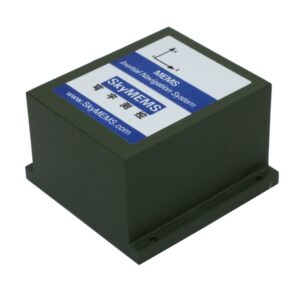
Comparison Table: INS vs GPS vs Integrated System
| Merkmal | INS | GPS | INS + GPS |
| Position type | Relative | Absolute | Hybrid |
| Drift | Ja | Nein | Corrected |
| Signal dependency | None | Required | Partial |
| Abfragerate | Sehr hoch | Low-medium | Hoch |
| Accuracy stability | Degrades | Stable | Stable |
Industry Insight: Modern INS Development
The INS industry is evolving rapidly thanks to advancements in sensor fusion, miniaturisation, and AI-driven navigation algorithms.
Sensor fusion technology
- Integration of INS with GPS, LiDAR, radar, and vision systems
- Improved accuracy and reliability in complex environments
- Reduced dependence on a single positioning source
Miniaturisation and MEMS technology
- Adoption of MEMS-based inertial sensors
- Smaller, lighter, and lower-cost INS units
- Enables deployment in drones, wearable systems, and compact robots
Enhanced accuracy and drift compensation
- Advanced algorithms reduce inertial drift over time
- Real-time correction using GNSS data
- Improved long-duration navigation stability
AI and machine learning integration
- Predictive motion modelling
- Adaptive sensor calibration
- Improved performance in GPS-denied environments
Growth of autonomous systems
- Expansion of autonomous vehicles and drones
- Increasing demand for high-reliability navigation systems
- INS+GPS becoming a core enabling technology
Resilience in GPS-denied environments
INS provides backup navigation when GPS signals fail, which is critical for defence, underground, and indoor applications.
Advantages of INS + GPS Integration
Combining an Inertial Navigation System (INS) with GPS creates a hybrid navigation solution that capitalises on the strengths of both technologies. This combination is widely used in aerospace, autonomous systems, surveying, and defence applications, where high levels of accuracy, continuity, and reliability are required.
- High positioning accuracy
One of the biggest advantages of INS + GPS integration is improved positioning precision.
GPS provides absolute global positioning, while INS delivers high-frequency motion tracking. When combined, they significantly reduce positioning errors and improve overall accuracy.
- Continuous navigation without signal gaps
GPS signals can be interrupted in the following environments:
- Tunnels
- Urban canyons
- Dense forests
- Underground areas
INS compensates for these gaps by providing dead reckoning navigation.
This ensures uninterrupted positioning data at all times.
- Reduced INS drift errors
Standalone INS systems accumulate drift over time.
With GPS integration:
- GPS periodically corrects INS drift
- Long-term accuracy is significantly improved
- Navigation remains stable over extended operations
- High update rate and real-time response
INS provides high-frequency motion data (attitude, velocity, and acceleration), while GPS provides lower-frequency, absolute positioning updates. The fusion delivers real-time, smooth, and responsive navigation output.
- Improved performance in dynamic environments
INS + GPS systems perform exceptionally well in:
- High-speed vehicles
- Aircraft and UAVs
- Marine navigation under wave motion
- Industrial robotics with complex movement
They maintain accuracy even under rapid acceleration or vibration.
- Strong resistance to signal interference
- INS is immune to electromagnetic interference and jamming
- GPS provides a global reference when signals are available
- Together, they form a more robust and resilient navigation system.
- Enhanced reliability and redundancy
The integration provides a dual-system safety mechanism:
- If the GPS fails, the INS continues to operate.
- If the INS drifts, the GPS corrects it.
This redundancy is critical for mission-critical applications.
- Better sensor fusion capabilities
Modern INS + GPS systems often integrate with:
- LiDAR
- Radar
- Vision systems
This improves environmental awareness and positioning robustness.
- Optimised for autonomous systems
INS + GPS integration is essential for:
- Autonome Fahrzeuge
- UAV drones
- Robotic systems
It ensures:
- Stable path tracking
- Accurate localisation
- Safe autonomous decision-making
- Cost-effective, high-performance navigation
Compared to ultra-precision standalone systems:
Integration reduces dependency on expensive single sensors and achieves high performance through sensor fusion.
Emerging Trends (2026 and Beyond)
- AI-enhanced navigation
Machine learning improves both drift correction and prediction accuracy.
- Multi-Sensor-Fusion
INS, GPS, vision, and radar systems.
- GNSS-denied navigation
Critical for defence and autonomous systems.
- Miniaturisation
MEMS INS for smartphones, wearables, and drones.
FAQ: Inertial Navigation System with GPS
What is an Inertial Navigation System with GPS?
It is a hybrid navigation system that combines INS motion sensing with GPS satellite positioning for accurate and continuous navigation.
Why is GPS combined with INS?
Because INS drifts over time, while GPS provides drift-free absolute positioning.
What is the main advantage of INS/GPS systems?
They provide continuous, accurate navigation even when GPS signals are temporarily unavailable.
Where are INS/GPS systems used?
They are used in aircraft, drones, autonomous vehicles, ships, and robotics.
What algorithm is used to combine INS and GPS?
A Kalman filter or its variants are commonly used for sensor fusion.
Schlussfolgerung
An inertial navigation system with GPS integration is one of the most significant developments in modern navigation technology. By combining the continuous motion tracking capability of an INS with the absolute positioning accuracy of a GPS, the system achieves robust, high-frequency, and drift-corrected navigation.
This hybrid architecture is now the backbone of navigation in the aerospace industry, as well as in autonomous vehicles, robotics, and precision defence systems. Manufacturers such as SkyMEMS are continuing to innovate in this field by developing higher-precision, lower-drift, and AI-enhanced inertial navigation solutions.
In essence, INS + GPS is more than just a combination of two technologies — it is a fusion architecture that defines modern intelligent navigation systems.