33")


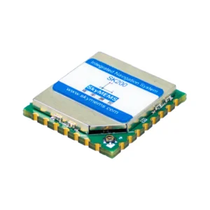
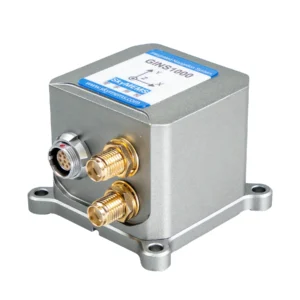
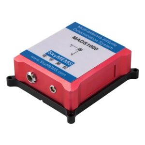
The GINS2000 High-Performance GNSS/INS Integrated Navigation System adopts high-precision MEMS inertial components and an RTK-enabled GNSS receiver module. It leverages SkyMEMS’ proprietary integrated navigation fusion algorithm along with multiple compensation techniques, enabling high-sensitivity signal tracking and accurate positioning even in harsh environments.
The system features a compact size, lightweight design, cost-effective pricing, low power consumption, fast start-up, and high reliability. It also offers excellent adaptability to dynamic environments. Thanks to these advantages, it has been widely applied in unmanned aerial vehicles (UAVs), ground vehicles, surface vessels, ships, precision agriculture, and other fields.

Typical Applications
GINS2000 GNSS/INS Integrated Navigation System is a high-performance integrated navigation system, it enjoys high reliability, high stability in dynamic applications, which has been widely used in the following fields:
– Unmanned Aerial Vehicle
– Small Plane
– Vehicle Navigation
– Surface Craft
– Platform Stabilization

GINS2000 GNSS/INS Integrated Navigation System widely used in UAV Navigation
UAV is unmanned aerial vehicle, commonly known as a drone, is an aircraft without a human pilot aboard. The flight of UAVs may operate with various degrees of autonomy: either under remote control by a human operator or autonomously by onboard computers.
GINS2000 GNSS/INS Integrated Navigation System is a low-cost high performance integrated navigation system, which has been widely used in unmanned UAV Navigation.

GINS2000 GNSS/INS Integrated Navigation System is a low-cost high-performance integrated navigation system, which has been widely used in construction machinery.
For construction machinery, the Integrated Navigation System can provide real-time positioning and precise attitude information (heading, roll, pitch), assist autonomous operation and path control, improve equipment stability and operational accuracy, and reduce the impact of vibration, slope, and harsh environments. Even in complex construction sites, the continuity and reliability of navigation data can still be ensured. Machine status and operation data can be transmitted to monitoring centers through communication devices to improve construction efficiency and operational safety.

GINS2000 GNSS/INS Integrated Navigation System widely used in small plane
GINS2000 GNSS/INS Integrated Navigation System is low-cost high performance integrated navigation system, which has been widely used in civil planes.
The integrated navigation system can determine the real-time position of civil planes, monitor the attitude (heading, roll, pitch) of civil planes, facilitate pilots to grasp the real-time flight status of the aircraft. The communication equipment can transmit position and attitude information to the control center, assisting the air traffic control center in monitoring the status of civil planes to ensure navigation safety.

GINS2000 GNSS/INS Integrated Navigation System widely used in Autonomous Vehicles
A high-precision Integrated Navigation System can accurately determine and track the position and attitude of a vehicle. When driving, the direction and position of unmanned vehicles are extremely important. Driving in a slightly wrong direction, even briefly, may cause the autonomous vehicle to enter the wrong lane. The dynamic control of autonomous vehicles requires sensors with dynamic response. Integrated Navigation System can provide real-time dynamic attitude and position changes of the vehicle.
Integrated Navigation System provide reliable performance with good accuracy in dynamic environment, it has been widely used in autonomous vehicles by the Chinese leading companies.
Why Selecting GINS2000 GNSS/INS Integrated Navigation System?
GINS2000 GNSS/INS Integrated Navigation System is designed and produced by SkyMEMS, it enjoys high performance and accuracy, and high reliability. It is a popular GNSS/INS system in the market, which has the main following advantages:
1.High Accuracy, High Performance and Powerful Functions

GINS2000 GNSS/INS Integrated Navigation System is a high-performance integrated navigation system, which enjoys excellent technical advantages:
– GPS/BDS/GLONASS/Galileo/QZSS Systems, Full-Frequency GNSS Receiver
– High Tracking Sensitivity for Complicated Environment
– High Accuracy: yaw up to 0.1°, Pitch/Roll: 0.1° (rms), Velocity <0.03m/s, Position < 2cm (rms, RTK)
– High Reliability, Strong Vibration and Shock Resistance
– Multiple Interfaces: RS232 / RS422
– Adjustable Bandwidth and Protocol ODM Supported
GINS2000 GNSS/INS Integrated Navigation System adopts big brand components, advanced production craft, fully calibrated, advanced SkyMEMS algorithm, which assured that our products have real actual precise and perfect performance.
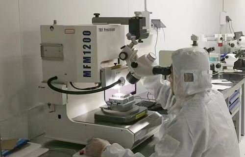
2.Aerospace Level Reliability, 12-step Strictest Quality Control

We have advanced product test team and measurement equipment, and we cherish the quality as the life of the company, all our products must pass the strictest quality control procedures, our unique 12-step quality control assures our products enjoy top level quality.
3.Competitive Price, ODM supported

With strict cost control and massive production, we can provide the most competitive cost-effective prices, and we have abundant ODM service experience for customers around the world, that is why we can build up long term win-win cooperation with our customers.
4.Successful Applications in many Fields, 300+ Customers are Using

We are continuously focusing on MEMS measurement & control technologies, and have developed the most advanced GNSS/INS Integrated Navigation System GINS2000. and GINS2000 has been widely used in unmanned aerial vehicle, ship and boat, vehicle navigation, surface craft, civil plane, etc. and now more than 300 customers are using our GNSS/INS Integrated Navigation System around the world.
5.World-class Production Line, Fast Delivery

We have the world class production line to assure that the production procedures are scientific, precise, and normative, which also can assure our products to be fast delivered.
6.Service with Heart, Professional Technical Support

We have the professional technical support engineer team, which can provide 24-hour technical support and excellent after-sale service.
Serving customers with heart is the principle of SkyMEMS, Customer demand is the fundamental driving force of our development.
We treat our customers with heart, customers’ satisfaction is the direction and target of SkyMEMS. Through continuously technology innovation and service upgrading, we will realize win-win cooperation with customers.
Q: What is GNSS/INS Integrated Navigation System?
A: Global Navigation Satellite System (GNSS) receivers provide position coordinates and the velocity vector with data rates of 1 – 10 Hz. However, they require data from at least 4 GNSS satellites, which often is not the case e.g. within urban canyons of the big cities.
Navigation systems are based on accelerometers and gyroscopes, so called Inertial Navigation Systems (INS), provide position, velocity as well as attitude with data rates of typically 1 kHz. Thus, they are the primary sensors for the Guidance, Navigation and Control (GN&C) system of aircrafts, rockets and satellites. They work without any external aiding information. However due to the inherent bias errors of the inertial sensors an INS has an unbounded position error growth over time.
The fusion of both systems by means of a Kalman estimator uses the advantages of these complementary sensors, resulting in a smooth data stream of position, velocity, and attitude with high data rate, now with bounded errors. Additionally, such an Integrated Navigation System is able to calibrate the inertial sensor bias errors in flight. A tight coupling of the pseudoranges and deltaranges of the GNSS receiver with the INS data provides reliable position coordinates even if less than 4 GNSS satellites are visible. In a further step by a deep GNSS/INS integration, which couples the tracking loops of the GNSS receiver with the INS data, it is possible to track even those satellites, which are not visible for some period of time, which allows instantaneous recovery of lost satellite signals.
Q:What data can the Integrated Navigation System provide?
A: When the Integrated Navigation System is installed on a carrier and used in conjunction with a GNSS antenna, the integrated navigation system can provide information such as the carrier’s position (longitude, latitude, altitude), speed, attitude (heading, pitch, roll), angular velocity, acceleration, etc.
Q: Whether the GINS2000’s UART dataoutput rate can be settable?
A: yes, we can, the GINS2000 UART data output rate is 100Hz typically, you can set it by GINS2000’s host software. If you want to set it above 100Hz, please let us know, we can set it here in our factory.
Q: Whether SkyMEMS can provide ODM service based on GINS2000module?
A: yes, we can, we can design the Integrated Navigation System based on your actual application, and also optimize our algorithms to make it right suitable for your application. While the size and shape may be changed according to your actual applications.
Q: What is the Relation to guidance and control?
A: Navigation is concerned with determining where you are relative to where you want to be.
Guidance is concerned with getting yourself to your destination.
Control is concerned with staying on track.
There has been quite a bit of synergism among these disciplines, especially in the development of missile technologies where all three could use a common set of sensors, computing resources, and engineering talent. Therefore, the history of development of integrated navigation technology has a lot of overlap with that of guidance and control.
Q: What is Aircraft Axes Definition?
A: The three axes of the aircraft are:
The roll axis which is roughly parallel to the line joining the nose and the tail
Positive angle: right wing down
The pitch axis which is roughly parallel to the line joining the wingtips
Positive angle: nose up
The yaw axis is vertical
Positive angle: nose to the left
Q: How about the delivery time?
A: for our standard model, if we have them in stock, only need 2~3days to re-test before shipping, if it is out of stock, then need around 2 weeks to arrange the production and tests. For the ODM electronic product, if needing to modify the structure, it will need around 3~4 weeks to arrange the production and tests.
Q: How to arrange the payment?
A: about the payment, please pay to our company account, the beneficiary’s name: NANJING SKY MEMS TECHNOLOGY CO., LTD. And our email is only @skymems.com to contact with u formally. To notice this to avoid the loss.